
Roads glitter at dawn, reservoirs steam faintly, and breath hangs like ghostly lace. It’s the kind of cold that reshapes a day before it’s even begun.
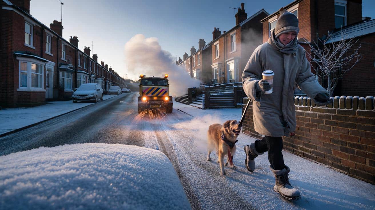
The frost hit before the alarm did. Out on a terraced street in Leeds, windscreens wore a milky glaze, and the pavement sang that brittle, glassy crunch that only arrives when the mercury has nosedived. A neighbour tugged at a frozen door handle, the sky barely a suggestion over the rooftops, and the dog walkers moved like careful acrobats, one gloved hand on a garden wall for balance, the other cupped round a takeaway coffee. On the radio, the words “Arctic air mass” felt bigger than the kitchen, echoing off tiles and windowpanes already misting. You could feel the cold deciding things for you. Then the traffic bulletin slipped in a single, ominous phrase. Black ice.
What the Arctic air is doing to the UK right now
Across the North Sea coast, narrow bands of showers have been spiralling inland, laying thin streaks of powder across fields and A-roads, then freezing into a slick crust by late afternoon. In the Highlands and Cairngorm foothills, pockets of -9C to -12C have been recorded on valley floors, the kind of readings that make fence wires ping when touched and turn puddles into plates. City centres look calm from a distance, lights soft and golden, but walk out and your breath grains into tiny crystals that sparkle in the streetlamps. The cold is not loud. It is insistent.
At 3.20am in Northumberland, Paul, a gritter driver, watched the road temperature crawl down on his cab display and flicked the spinner a notch higher; grit pattered against the chassis like sand on a drum. Rail operators trimmed a few first-wave departures to buy time for de-icing, and two rural bus routes in the Dales posted shorter loops after hilltops iced early. National Grid data often shows demand leaping by roughly a third on days like this, and you could feel that in the flurry at petrol stations and the soft hum of boilers across cul-de-sacs. The country wrapped itself tighter and carried on.
The setup is classic. A blocking high to the west funnels a northerly flow straight out of the Arctic, cold air deep down through the column, then clear nights for radiative cooling that lets ground frost bite hard. Sea-effect snow is a quirk of geography: air mass meets comparatively warm North Sea, picks up moisture, then dumps it in streamer lines over the first bit of land it greets. Some places stay bone-dry and glittery, others get repeated dustings. The daytime “ice day” risk—when air temperature never lifts above 0C—adds a sting, because **wind chill** drags the feel of -3C into -10C territory and keeps it there under the breeze.
Staying warm, moving safely, spending less
Start with small, precise steps. Before dawn, flip your heating for a short, earlier cycle so walls warm gently, then bleed the radiators that gurgle and stay cool at the top. For the car, use proper de-icer and a plastic scraper; lay a towel over the windscreen the night before, and clear snow from the roof so it doesn’t slide forward at the first brake. Inside, layer with a wick-first approach: merino base, fleece mid, windproof shell. A hot-water bottle at your feet under the desk is quietly magical, and **sub-zero** mornings are when draught stoppers and heavy curtains punch above their weight.
Common traps sneak up on the best of us. Pouring boiling water on glass can crack it, and driving with a tiny “peephole” in the frost isn’t brave, it’s blind. Drying clothes on radiators chokes rooms with damp, which chills you and fattens bills, so use an airer near a slightly open window or a fan on low. Trainers with smooth soles turn pavements into skating rinks; grippy boots make you feel human again. We’ve all had that moment when the path looks wet and honest, then slides away underfoot like oiled marble. Let’s be honest: nobody does that every day.
On days like these, forecasters sound less like scientists and more like town criers for good reason. Variation street by street matters.
“Wintry showers will be hit-and-miss, but ice is the headline hazard after sunset,” said Dr Maya Lewis, a Met Office meteorologist. “The smallest drop in temperature can flip damp roads to dangerous. Treat evenings as a fresh freeze.”
- Keep a simple kit in the car: scraper, de-icer, torch, blanket, water, high-energy snack, phone power bank.
- At home: close doors to hold heat in lived-in rooms, tuck towels at draughty thresholds, set thermostatic valves to consistent, low settings.
- For trips: build a 10-minute buffer, check rail and bus updates, walk on the crunchy bits, not the glossy ones.
What this freeze says about our winters
Cold snaps like this feel old-fashioned and a little mythical, yet they keep arriving in new shapes and rhythms. A string of tame winters can lull us, then a bracing Arctic outbreak reminds the bones what January means in a maritime island climate. Energy use surges, wildlife shifts routines—robins closer to porches, fox prints threading estates—and local economies wobble as deliveries miss tight slots. **Black ice** becomes a neighbourhood legend by mid-morning, everyone swapping tips and near-misses outside the corner shop. The big picture remains complicated: a warming planet doesn’t cancel cold spells, it scrambles the deck so the sharp days stand out against warmer averages. That tension sits in the air as surely as the frost, and it invites something we’re quietly good at here: swapping small solutions, keeping an eye on each other, and telling the day it can be tough without being unkind.
| Key point | Detail | Interest for the reader |
|---|---|---|
| — | Arctic air mass driving **wind chill** and “ice day” risk in exposed areas. | Helps you judge how it will actually feel, not just what the thermometer says. |
| — | Targeted tactics for cars, homes, and commutes that work on sub-zero mornings. | Turns a difficult start into a manageable routine, saving time and money. |
| — | What to watch next: clear nights, sea-effect snow lines, and post-sunset ice. | Lets you plan the day—and evening—around the most slippery moments. |
FAQ :
- How long could this cold spell last?Forecasters often flag a few days of northerly flow, then a pattern shift; the sting in the tail tends to be two or three nights of deep frost after the snow showers fade.
- What exactly is an Arctic air mass?It’s a pool of very cold, dense air that forms over high latitudes, then travels south on northerly winds; across the UK it can pick up moisture over the sea, which turns into wintry showers inland.
- Why does wind chill matter if the air temperature is the same?Wind strips the thin layer of warm air next to your skin and speeds heat loss, so your body feels colder and can get into trouble faster, especially for fingers, toes and exposed cheeks.
- Are school closures likely in this kind of cold?Closures are local decisions based on site safety and staff travel; a dry, bright -4C can be manageable, while a marginal 0C with ice can tip a headteacher toward closing for the day.
- How do I stop pipes from freezing?Lag exposed pipes, keep indoor doors open to let warmth circulate, let a very slight trickle run on the coldest nights, and know where your stopcock is in case you need to turn water off fast.


Any update on how long the northerly flow will stick around? Are rail de-icing delays likely to worsen by Friday morning, or will things ease off?
My car door is basically welded shut—any tips that don’t involve a kettlle and immediate regret?