
A thin glaze on the wheelie bin, a sparkle along the kerb, and breath that hangs like smoke: the Met Office has zeroed in on the parts of the UK where icy mornings will bite hardest this week. For commuters, dog walkers and school runs, this isn’t just “cold weather” — it’s that silent, slippery kind that turns pavements into traps and windscreens into milky sheets. The question isn’t if frost will form. It’s where it will grip most stubbornly, and why.
A gritter rumbles past, its tail scattering sparks of salt that clatter against parked cars, and a man with a mug of tea blows into his hands, weighing up whether to scrape now or finish his last sip. In the distance, a train horn cuts the air, and someone swears softly at a frozen lock. *The air tastes like the inside of the fridge.* Then your phone buzzes: Met Office alert, icy stretches likely in prone spots. One short line tugs the morning off its rails. Where, exactly?
Where the ice will bite hardest, and why the map isn’t random
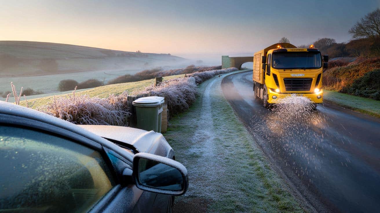
The Met Office’s latest guidance points to a familiar cold pattern: the sharpest starts across northern uplands and rural interiors, with frost pooling in hollows and valleys. Think the Scottish Highlands, the Pennine fringes, upland routes in Cumbria and mid-Wales, and sheltered spots of the Midlands where the wind drops out. Under clearer skies and slack isobars, radiative cooling does the quiet work, drawing heat from the ground into the night. Coastal fringes and big city cores hold a little more warmth, but step just a few miles inland and the crunch underfoot deepens. Cold pockets aren’t random. They sit where the land lets the chill settle.
Picture a delivery driver edging along a hedged lane in Northumberland at dawn, road crown glittering like glass, verges dull with rime. The farm gate is fine; the shaded bend beyond is an ice rink. That contrast plays out everywhere this week where skies have cleared after daytime showers, leaving damp ground primed to freeze. Rural minima often dip 2–4°C below nearby town centres, a small number that means everything when the tarmac crosses zero. **Urban islands of warmth can spare city cores, yet bridges, flyovers and car parks still go treacherous before breakfast.** The most slippery bit tends to be the one you don’t expect.
Three ingredients load the dice: clear nights, light winds and leftover moisture. Clear skies let heat leak away; a gentle or calm night stops the air mixing; damp surfaces lock in that freeze as a skin of ice. Cold air is heavier, so it drains like water into ditches, dips and river corridors, chilling the ground even more. That’s why a field can crunch while the hill above stays soft. Met Office high‑resolution models flag these “frost hollows” and shaded cuttings because topography steers the cold into them. Meltwater refreezes before dawn, and black ice forms where you only see tarmac. The science is neat. The reality is a slip, a slide, a gasp.
Staying upright and on time: small moves that beat big chills
Start the night before. Park facing east if you can to catch first light on the screen. Lift wipers, lay a towel or proper cover over the windscreen, and crack a window a fraction to reduce fogging inside. Leave ten extra minutes in the morning and pick gritted main roads over short cuts through shaded lanes. Keep a scraper, de‑icer spray and a microfibre cloth by the door, plus a pair of grippy-soled shoes for the first few steps. We’ve all had that moment when the path looks dry until your heel goes on its own adventure. Small prep, big dividends.
Go gentle on the first mile. Pull away in a higher gear, keep revs low, and build gaps like you’re double‑parking safety into the road. Scan for bridge decks and tree tunnels — they chill fastest and thaw last. **Do not pour hot water on your windscreen.** The thermal shock can crack glass and the splash can turn your drive into a rink. Let’s be honest: nobody really does that every single day. So choose the one or two habits you’ll actually stick to, like pocketing de‑icer and stepping like a penguin on glossy slabs. Your ankles will thank you at 7:42.
Keep a tiny winter kit by the door. A spray, scraper, head torch and thin gloves mean you’re not improvising with a bank card in the sleet.
“The cold you can see is rarely the one that catches you,” an old gritter told me, tapping the bridge rail before tossing another scoop of salt. “Feel the air. Shiny road, slow road.”
Line your routine with quick wins that feel human, not heroic.
- Windscreen trick: 3–5 short blasts of the heater on recirculate, then fresh air to clear fog fast.
- Footwork: tiny steps, feet slightly out, centre of gravity low on glossy pavements.
- Route hack: avoid cut-throughs with overhanging trees; they drip, then refreeze.
- Car sense: test brakes gently on a straight, empty stretch to read the grip.
A colder start with a silver lining
There’s a quiet beauty to a Britain rimmed with frost, from silvered allotments to roofs dusted like pastries. The same stillness that paints lawns also tricks ankles and spins wheels, which is why the Met Office map matters this week: it nudges our attention to the places that cool first and thaw last. Share the heads‑up with a neighbour, text your mate on the early shift, and lay a towel across the screen for the person you love who never finds gloves. A small kindness in the dark can turn a risky morning into a routine one. If you’re lucky, the sun will lift over a white field, and you’ll catch your breath at the sparkle before it drips away. **Cold passes. Stories linger.** The lanes will chatter again by nine, and you might be only five minutes late, with a tiny win to carry in your pocket.
| Key point | Detail | Interest for the reader |
|---|---|---|
| Frost hotspots | Rural interiors, upland fringes, valleys, bridges and shaded cuttings | Know where grip disappears first, plan safer routes |
| Timing | Pre‑dawn to mid‑morning under clear skies and light winds | Pick departure windows, avoid risk peaks |
| Simple fixes | Cover screens, carry de‑icer, choose gritted roads, penguin steps | Fast, doable habits that reduce slips and skids |
FAQ :
- Which parts of the UK face the sharpest icy starts this week?Expect the sting in northern and upland areas, rural interiors of Scotland, northern England and mid‑Wales, plus frost hollows and shaded valleys across the Midlands.
- Why do bridges and flyovers freeze before the rest of the road?They’re exposed to cold air above and below, so heat escapes faster and ice forms sooner.
- Is black ice visible?Rarely — it looks like ordinary wet tarmac; treat any dark, glossy stretch in sub‑zero air as slippery.
- Can salt stop ice completely?Salt lowers the freezing point and helps, but thin refreezes still happen where traffic is light or moisture keeps dripping.
- What’s the safest way to clear a frozen windscreen?Use de‑icer and a scraper, run the blower on low with the A/C on, and clear all glass before moving off.


So basically, Britain’s a giant penguin‑waddle zone this week. Got it.