
Across the continent, pavements are buckling, church towers lean by millimetres each year, and old canals creep closer to front doors. Scientists say it isn’t imagination. The ground under parts of Europe is quietly sinking, sliding, and compacting — not in a dramatic plunge, but in a slow, stubborn shift.
A man on a bicycle pointed at a line on a wall — an old high-water mark — now almost at his shoulder. “It wasn’t there when I was a boy,” he said, and then pedalled off, as if it were a normal thing to mark your childhood against the sinking of a city.
It felt ordinary and alarming at once. The café awning hung a touch off-level, and a damp, sour smell lifted from the cobbles. You start to notice the small tilts when someone points them out, the way you start hearing a fridge once it hums louder. Europe isn’t falling into a hole. It’s changing shape. And not always the way we hoped.
A simple question lingers: what’s pulling us down?
The ground is not still, and it never was
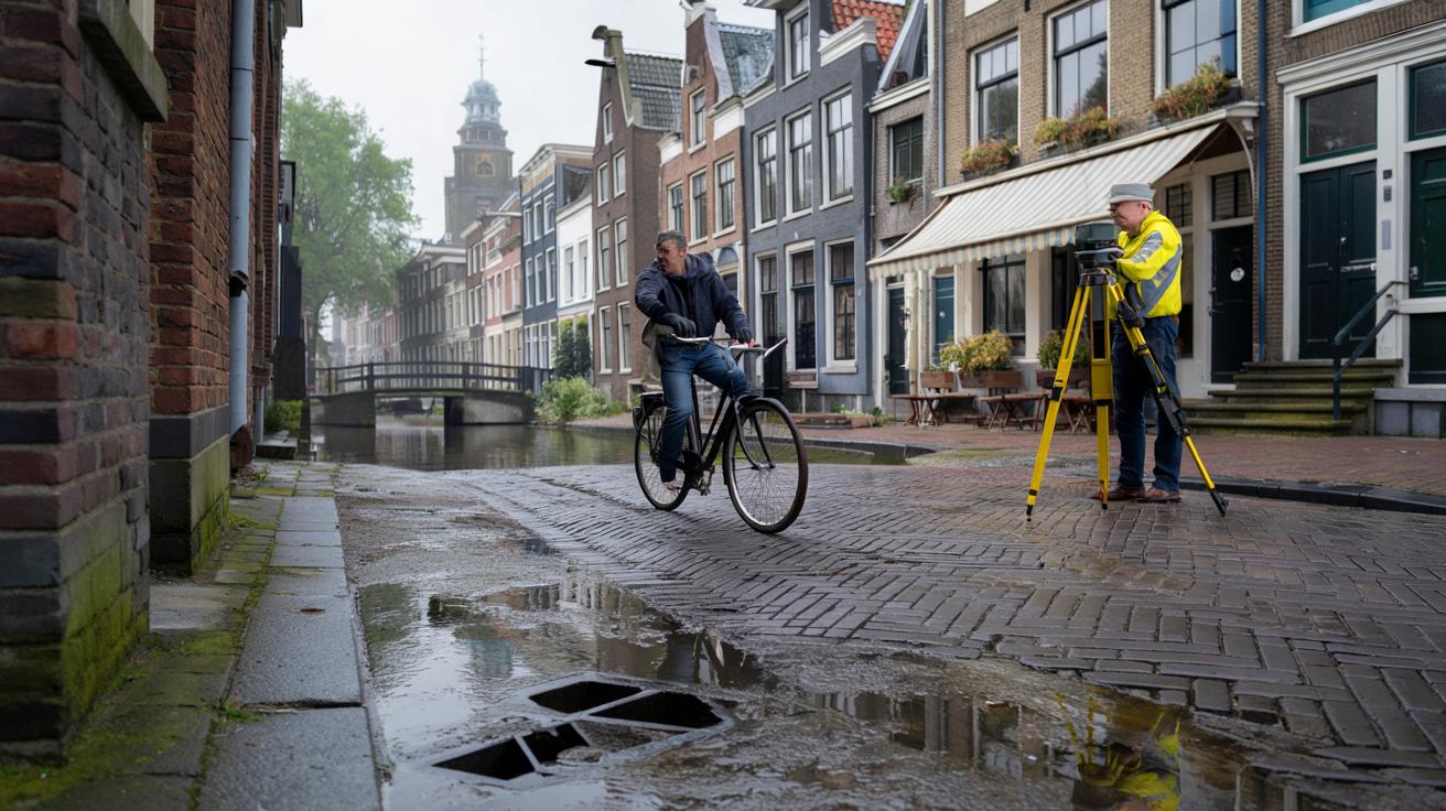
Walk through Amsterdam on a rainy Tuesday and you’ll see houses leaning on each other like old friends. That charm comes with a physics lesson. Clay and peat soils compress over time, especially as cities get heavier and drier soils oxidise. Add in tides along estuaries and the gentle flex of the Earth’s crust, and you have a city that subtly rearranges itself. **Parts of Europe are literally sagging under our feet.** Most days you won’t feel it. Your phone will buzz, the tram will swing by, and life will keep stacking more weight on the same soft ground.
In northern Netherlands, the Groningen gas field brought decades of prosperity and a scattering of shallow earthquakes. Farmers there tell a simple story: a crack that wasn’t in the plaster last winter is there now. Statistics back it up; satellite radar has clocked subsidence in pockets of the region in the order of millimetres per year, with local spikes where extraction and soft sediments line up. Venice shows the same truth in a different costume: compaction of lagoon sediments, historic groundwater pumping, and the load of a stone city pressing into mud. You can map it, but you can also see it in the waterline scuffs on brick.
Scientists divide the culprits into a few big families. One is isostasy — the slow rebound of land freed from ancient ice sheets in Scandinavia, which nudges southern Britain and parts of the Low Countries downwards as the north rises. Another is compaction: clay and peat lose volume when drained or loaded, a long squeeze that barely pauses. Then there’s us: mining, pumping water, building heavy infrastructure, even draining wetlands for farmland. Each choice shifts weight and pressure underground. It’s not a catastrophe movie. It’s a ledger, and the sums are catching up.
How to read the street — and the science — like a local
Start with eyes and a notebook. Notice doors that stick at certain times of year, hairline cracks that widen after dry summers, or puddles that take longer to clear on familiar corners. Mark them, even with photos. When tides run high or storms press water inland, watch where water collects and how it flows. That’s your personal map of ground behaviour. It feels low-tech, yes, but patterns jump out over a season. Your street has habits. So does the soil under it.
Let’s be honest: nobody checks their foundations every single month. The trick is to tie it to real life. After a heatwave, look for new settling. After a week of rain, check gutters and basements. In soft-ground cities like Rotterdam, Hamburg, or London’s Thames-side districts, small moves can signal bigger underlying shifts. And if you live on former peat or marsh, you’re living on material that shrinks when dry and swells when wet. You’re not imagining that wobble on the garden path. You’re measuring the year with your feet.
One more lens helps — satellites. **Researchers now use InSAR, a radar technique from space, to measure ground motion down to millimetres.** The data is public in many countries, and local councils often know their hot spots. Ask them. If it all sounds abstract, try this: compare the height of your ground floor with your street drain every couple of years. When those lines start to flirt, it’s a warning sign.
“We used to guess based on a few survey points,” says a coastal engineer in the Po Delta. “Now we watch entire districts breathing in slow motion.”
- Check national geological surveys for local subsidence maps.
- Photograph cracks with a coin for scale and a date stamp.
- Log stuck doors, pooling water, and shifting steps after extreme weather.
- Share patterns with neighbours — trends matter more than one-off scares.
What’s really pulling Europe down — and what might lift it
Not every cause is modern. Scandinavia is still springing back from ice that melted thousands of years ago, lifting the north and tilting parts of the south. That see-saw makes sea levels feel different from place to place. Then there’s plain old geology: thick river sediments in the Rhine–Meuse–Scheldt delta and the Po Valley compact over time, and cities built on them add another layer of pressure. *Stability, in Europe, is often a moving target.*
Water is both culprit and cure. Drain peat to farm it and the soil oxidises, sinks, and emits carbon. Re-wet it and you slow the drop, sometimes dramatically. Pump aquifers hard and ground can settle as pore pressure falls; recharge them and the trend can ease. Italy restricted groundwater pumping around Venice decades ago, and the fastest sinking slowed. It didn’t rewind history. It bought time. The same idea plays out from Polish coal basins to Spanish citrus belts: how much we take, how fast we drain, how heavily we build — all show up in the ground.
There are fixes that feel humble and fixes that feel grand. Raise streets and quays in the places that can’t move, as Venice is trying with MOSE barriers and staggered public works. Shift crops and restore wetlands where subsidence meets flood risk, a strategy spreading across Dutch peat meadows and the Ebro Delta. Engineer lighter buildings on piles that reach stable layers, and design parks that flood gracefully so homes don’t. **No single lever will stop the slow slide everywhere.** What we do get is a menu — and the choice to start before the line on the wall creeps up again.
In Copenhagen’s Nordhavn, new districts use floating walkways and stepped quays that accept occasional submergence. It’s less a surrender than a clever shrug: if the ground is going to settle a touch, meet it halfway and let water in where it does the least harm. In Groningen, buyouts and retrofits are pairing with a slow phase-out of gas extraction. In Naples and Pozzuoli, where the ground swells and sinks from volcanic fluids, residents get text alerts ahead of inspection campaigns. We’ve been here before, just with fewer tools. Now the map is sharper, and the clock is louder.
Europe’s shifting ground is a reminder that change is ordinary, even when it’s unnerving. The science is clear, the stories are everywhere, and the choices are ours. Think of the continent as a big old house: some rooms need propping, some doors need planing, some leaks want fixing before storm season. On a foggy morning by the river, you can feel the hush between two passing trains. We’ve all had that moment when the world goes quiet and you notice what’s beneath you. That’s the moment to pay attention.
| Key point | Detail | Interest for the reader |
|---|---|---|
| Multiple causes | Isostatic tilt, soft-soil compaction, extraction, and urban load | Helps make sense of why some streets sink while others don’t |
| Measurable rates | Millimetres per year detected by InSAR and ground surveys | Turns vague worry into numbers you can track or ask about |
| Action menu | Re-wetting peat, smarter building, floodable parks, targeted pumping | Practical steps to protect homes and neighbourhoods |
FAQ :
- Which parts of Europe are sinking the most?Hot spots often include deltas and soft-ground cities: the Netherlands’ peat regions, Italy’s Po Delta and Venice, parts of coastal Germany, and areas affected by mining or groundwater extraction.
- How fast is the ground actually moving?Typical rates run a few millimetres per year, though local peaks can be higher where soils are very soft or extraction has been intense. Satellites help pinpoint those pockets.
- Is climate change involved?Indirectly, yes. Longer droughts dry and shrink peat and clay; heavier downpours stress drainage and foundations. Sea-level rise then compounds the risk in low-lying zones.
- Can subsidence be reversed?True reversal is rare. You can slow it — by re-wetting peatlands, reducing pumping, and building smarter — and you can adapt streets and drainage to cope better.
- What should homeowners look for?New cracks that widen with seasons, doors that start to stick, pooling after normal rain, and changes in the height gap between your floor and street drains. Document patterns, not one-offs.


Wild to think the ground is ‘breathing’. Thanks for the clear write-up! 🙂